Back ميبل هايتس (أوهايو) Arabic ميبل هايتس ARZ میپل هایتس، اوهایو AZB Maple Heights Catalan Мейпл-Гайтс (Огайо) CE Maple Heights CEB Maple Heights, Ohio Welsh Maple Heights German Maple Heights (Ohio) Spanish Maple Heights (Ohio) Basque
Maple Heights, Ohio | |
|---|---|
 Residential neighborhood along Vine Street | |
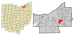
 Location in Cuyahoga County and the state of Ohio. | |
| Coordinates: 41°24′44″N 81°33′35″W / 41.41222°N 81.55972°W | |
| Country | United States |
| State | Ohio |
| County | Cuyahoga |
| Incorporated | 1915 |
| Government | |
| • Type | Mayor-Council |
| • Mayor | Annette M. Blackwell |
| Area | |
| • Total | 5.17 sq mi (13.39 km2) |
| • Land | 5.17 sq mi (13.39 km2) |
| • Water | 0.00 sq mi (0.00 km2) |
| Elevation | 896 ft (273 m) |
| Population (2020) | |
| • Total | 23,701 |
| • Density | 4,585.22/sq mi (1,770.30/km2) |
| Time zone | UTC-5 (Eastern (EST)) |
| • Summer (DST) | UTC-4 (EDT) |
| ZIP code | 44137 |
| Area code | 216 |
| FIPS code | 39-47306[3] |
| GNIS feature ID | 1048945[2] |
| Interstates | |
| Rapid Transit | |
| Website | https://www.citymapleheights.com/ |
Maple Heights is a city in Cuyahoga County, Ohio, United States. It is a suburb of Cleveland. The population was 23,701 at the 2020 census.
- ^ "ArcGIS REST Services Directory". United States Census Bureau. Retrieved September 20, 2022.
- ^ a b U.S. Geological Survey Geographic Names Information System: Maple Heights, Ohio
- ^ "U.S. Census website". United States Census Bureau. Retrieved January 31, 2008.

